Drone archaeology is now the standard for mapping historical sites with greater precision and productivity. For over a century, the field relied on labor-intensive methods like manual sketches and slow physical measurements.
Researchers once spent months grid-mapping sites with tape measures, string, and hand-drawn layouts. While these traditional methods formed the foundation of archaeology, they often lacked a precise global scale and failed to account for the broader landscape context.
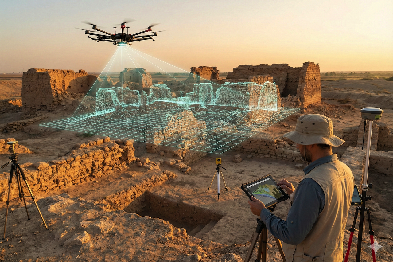
A digital transformation is now underway at historical sites. Using uncrewed aerial vehicles, researchers convert physical ruins into high-resolution geolocation data. This switch from manual surveying to drone 3D scanning ensures ancient ruins are preserved as accurate digital assets.
These unmanned systems bridge the gap between ancient history and modern mapping techniques. Rather than excavating physical sites alone, researchers now create digital representations that preserve the past for future generations.
Why Geolocation Data Matters in Archaeology
Accurate geolocation data forms the foundation of every successful excavation and historical research project. In archaeology, where an object is found is often more important than what the object is. Without spatial context, an artifact loses its historical story. Modern geospatial mapping, including technologies such as drone archaeology and aerial surveying, enables this precision and allows researchers to move beyond simple discovery into complex spatial analysis.
The Critical Roles of Geolocation in Research
The inclusion of high-precision location data has fundamentally altered the scientific workflow. Attaching all finds to a global coordinate framework allows researchers to accomplish several extremely important goals:
- Creating Spatial Context: It is essential to understand how buildings or artifacts interact across large areas. For example, the exact distance between a residential location and a religious site can reveal much about past social hierarchies.
- GIS Layering: Geographic Information Systems allow professionals to organize data collected during discovery by elevation, soil type, and age. This stratigraphy aids the visual representation of how a civilization developed and evolved in response to its surrounding environment over the centuries.
- Predictive Modeling: Software can determine the location of undiscovered ruins by analyzing the geolocation data of known sites. Targeted archaeology saves years of fieldwork by narrowing the search area.
- Permanent Records: Physical sites are always at risk from erosion, war, and urbanization. Digital footprint leaves an irreversible mark. It guarantees that, even if a site is destroyed, its data is not lost and can be analyzed later.
This process resembles modern civil engineering. Archeologists require an accurate map of power lines in a city just as power lines require precise mapping. Reliable geolocation data ensures that all findings are recorded for researchers worldwide to study, without setting foot on the ground.
Role of Drones in Modern Archaeological Surveying
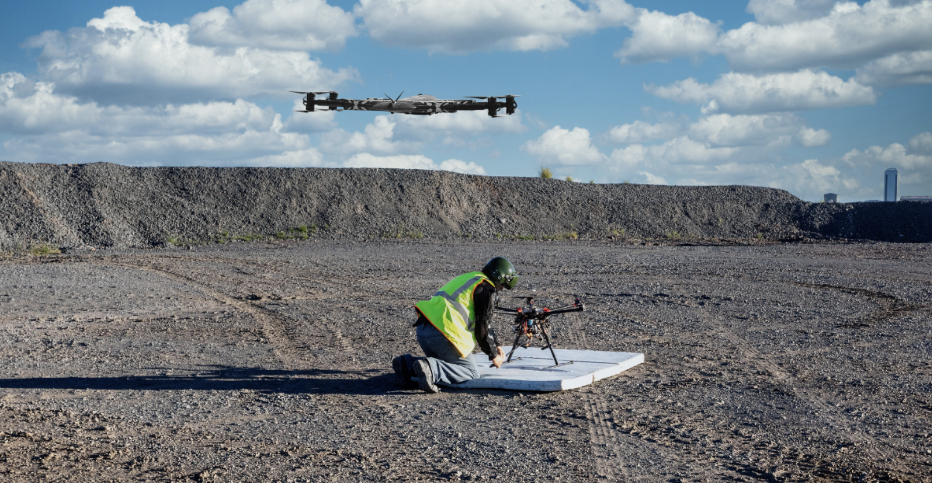
Drone archaeology has redefined the possibilities for field research. The use of drones has democratized high-altitude data collection, enabling small research teams to perform professional-grade aerial surveying with a single device.
The introduction of drones in archaeological work follows a systematic working process. For example, in the current excavation of the Lost Egyptian City, the project was initiated through photogrammetry. The drone covered the site methodically, in a pattern like a lawnmower, capturing hundreds of overlapping high-resolution images to document the ruins. Special software combined these photos to create a detailed 3D model of the city, revealing features such as old pathways and hidden structures. This example shows how these methods can change archaeology by making it easier to collect data and share findings visually. A drone operates like a mobile lab, gathering millions of data points much faster than a ground crew could measure even a single courtyard.
Advantages Over Traditional Ground Surveys
Traditional surveys are usually time-consuming and intrusive. Teams have to brush clear, install equipment, and manually determine coordinates. Such a practical approach is error-prone and can take months to cover a large area. Drone archaeology offers a non-invasive method to research a site, preserving it:
- Minimal Site Disturbance: Drones fly over ruins, thus they do not move or destroy fragile buildings.
- Comprehensive Coverage: Ground teams cannot see patterns visible only from height, such as a shadow mark that appears at sunset or sunrise.
- Cost-Effectiveness: Drone surveys are significantly more cost-effective than traditional excavations or helicopter surveys. This implies that additional funds can be allocated to lab analysis and carbon dating.
Safety, Speed, and Data Accuracy Benefits
Drones have an immediate effect on the safety and efficiency of field teams. Many important archaeological sites are found in difficult or dangerous places.
- Enhanced Safety: Drones enable investigators to survey hazardous or unstable locations from a safe distance, such as falling ruins or mountainous cliffs. This highly reduces the risk of injury.
- Rapid Data Collection: UAVs can survey hundreds of acres in a single afternoon, which on the ground would have required weeks of work. This speed is vital to rescue archaeology when construction or natural decay threatens a site.
- Superior Accuracy: Ground Sample Distance (GSD) enables drones to capture extremely high-resolution images that reveal fine details, ranging from a few centimeters to a few millimeters. This produces accurate 3D data and highlights details that individuals cannot see with the naked eye.
- Research Efficiency: Drones replace manual mapping, which is labor-intensive, so archaeologists will not need to clear sites and can devote more time to analysis and data interpretation.
How LiDAR Technology Reveals Hidden Archaeological Features
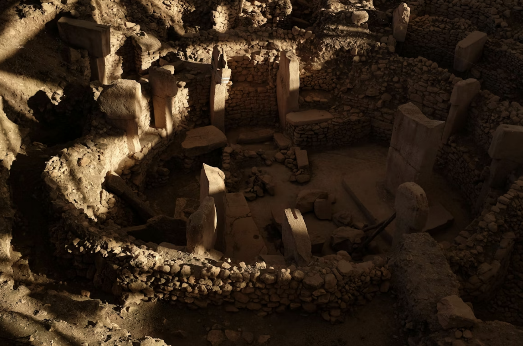
Drone LiDAR (Light Detection and Ranging) technology is the X-ray vision of contemporary archaeology. Although regular cameras have a direct line of sight only when observing the surface, LiDAR uses active laser pulses to penetrate thick forest canopies. This capability to traverse vegetation makes LiDAR mapping groundbreaking for site discovery. The process of exposing the hidden past entails several technical steps:
- Laser Emission: The drone sensor emits hundreds of thousands of light pulses per second toward the ground surface.
- Canopy Penetration: These pulses slip through small holes in leaves and branches, unlike light emitted by a camera. They collide with the real soil and concealed stone forms.
- Multiple Returns: The sensor captures returns from both the tree tops and the ground simultaneously.
- Bare Earth Modeling: The software removes noise from trees and bushes. This produces a "bare earth" digital terrain model (DTM) that reveals the actual topography.
Drone-based LiDAR mapping in archaeology has contributed to the identification of previously undocumented structures in densely forested regions such as the Amazon and the Mayan lowlands. Many of these features remained undetected for centuries due to vegetation cover. By using LiDAR technology, researchers can detect ancient roads, irrigation canals, and defensive walls that are not visible from the ground. This non-invasive method allows large-scale urban landscapes to be documented efficiently without disturbing the surrounding environment.
3D Scanning for Digital Preservation of Historical Sites

3D drone scanning generates a series of digital twins that can serve as a permanent backup for threatened historical sites. However, amid climate change, urban sprawl, and war, many of the ancient wonders of the world are at risk of extinction. The table below outlines the exact measures employed in the scanning operation and the way in which they can be used to protect our global heritage in the long term:
| Preservation Metric | Benefit for Archaeology |
|---|---|
| Spatial Precision | Records exact dimensions to monitor structural leaning or collapse. |
| Texture Detail | Captures surface weathering patterns for stone conservation. |
| Non-Invasive | Documents fragile sites without physical contact or site disturbance. |
| Data Portability | Allows global experts to collaborate virtually on a single 3D model. |
These scans are crucial to digital preservation, as they provide a blueprint for 1:1 reconstruction. In the event of damage to a monument, these digital files will help restore it in a historically accurate manner. Moreover, history is accessible through 3D models. Virtual tours allow students around the globe to explore remote ruins, preserving the actual location through the abuse of overtourism.
Integrating Drone 3D Scanning Into Archaeological Workflows
Modern archaeological surveying integrates drone data directly into professional GIS (Geographic Information Systems) software. The workflow begins with automated flight paths that ensure consistent image overlap. This data is then processed into textured, geographically accurate maps.
Technical Comparison: LiDAR vs. Photogrammetry
| Feature | Photogrammetry (Passive) | LiDAR (Active) |
|---|---|---|
| Data Source | High-resolution photographs | Rapid laser pulse reflections |
| Vegetation | Models the top of the trees | Reaches the ground under trees |
| Lighting | Requires clear, consistent sunlight | Works in low light or at night |
| Output | Life-like, photorealistic 3D mesh | Dense 3D point cloud |
| Best Use | Exposed ruins and visual reports | Hidden features and forest terrain |
Drone-enabled archaeological surveying methods often combine multiple data-capture techniques to improve spatial analysis. By integrating photogrammetric color data with the structural accuracy of LiDAR, researchers can generate detailed 3D spatial datasets that support historical interpretation and comparative analysis.
Broader Impact on Geolocation and Spatial Technologies
The spatial data accuracy developed in archaeology now has a significant impact on other global industries. The push for millimeter-level precision in mapping ancient temples has accelerated the development of sensors used in everyday life. Applications influenced by archaeological mapping include:
- Urban Planning: Transforming historical layers into sustainable smart cities designed with the help of drone scans.
- Infrastructure: 3D scanning-based monitoring of the health of modern bridges and power grids.
- Environmental Observation: Coasts and forests monitored using the same DTM techniques.
- Disaster Management: Quickly map cities during floods or earthquakes to develop evacuation routes.
The geolocation data used to locate a lost temple can also be used to track a melting glacier. Such tools assist in our control of the world. With archaeology pushing the limits of sensor resolution, we all benefit from the accuracy that has been developed to study our ancestors.
Conclusion: Connecting the Past With Digital Mapping
Drone 3D scanning transforms archaeology from a manual craft into a high-precision digital science. It has turned a slow, destructive process into a non-invasive, high-speed documentation method. By capturing precise geospatial mapping data, drones ensure that history is preserved with the same accuracy as our future cities. This technology provides insights into how human civilizations have interacted with their surroundings over millennia. With the advancement of sensor technology and its increasing availability, the relationship between ancient history and digital mapping will continue to gain momentum. Therefore, we now have a clearer, more comprehensive view of our history.
Featured Image generated by Google Gemini.
Share this post
Leave a comment
All comments are moderated. Spammy and bot submitted comments are deleted. Please submit the comments that are helpful to others, and we'll approve your comments. A comment that includes outbound link will only be approved if the content is relevant to the topic, and has some value to our readers.
Comments (0)
No comment